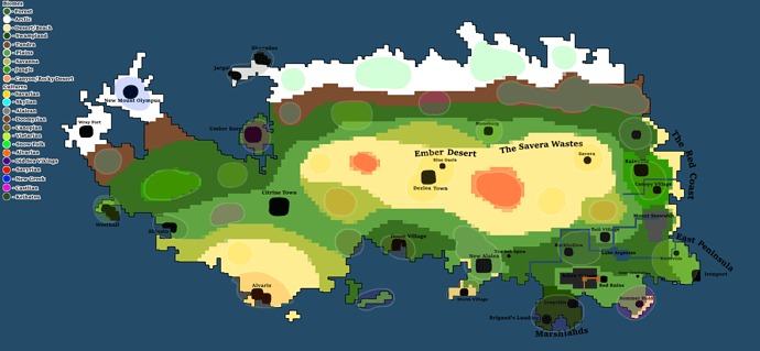
As previously explained in the thinking thread that I made on the forums, the Ngrwééy live in the bordering region between the Ember Desert and the northern grasslands above Citrine Town. The scaling earlier suggested that the maximum vertical distance in the image was 371px in height. However, the image I have on my system is larger and of higher quality, and instead measures at 880px.
Since I never directly stated where the maximum horizontal distance was on the forum post, I had to re-calculate it. It ended up being the line formed by the points (217,430) and (2113, 430) in the more high definition picture that I have saved on my flash drive. It is a long, horizontal line starting at the westward facing inlet near Wray Fort and ending at the peak of the land protrusion east of the settlement near Rainville. Using the 770:371 ratio used in the post, we assume that our image’s maximum horizontal distance is 1826.42px, or about 1826px, but it ends up being 1896px across. Close enough. Therefore, the ratio is 1896:880.
A note on the difference between a bay, a bight, and a gulf. A bay is a recessed, coastal body of water that directly connects to a larger body of water. A bight is any bend in a coast(line) or river or cliff or really any geographical feature, and can refer to a bay since the recession is often a bend inwards. A gulf is a large, narrow inlet from ocean into landmass. Practically, this means that a gulf is a narrower bay.
There are other terminology, like sound, inlet or fjord. An inlet is any indentation on a shoreline that leads to a larger body of water. A fjord is an extremely narrow inlet created by a glacier. That’s about as deep as I’m willing to go though.
I only write this because this confused the living hell out of me when researching geography.
It is still true that, assuming Magius were 9000km across, it would be about 4300km in height. More specifically, it’s 4177km, which can be estimated to being 4200km. This doesn’t matter – currently I want to deal with the Ngrwééy’s living space.
Looking at the diagonal distance from the two edges of the territory, we get a distance of 323.11px, which corresponds to about 1533.75km of territory across. Take into account the fact that the width of the territory is about 42.72px (202.78km), and we have a territory with a surface area of about 311,000km2, which is quite massive for a group of nomads to lay claim of, though it is significantly less unified than one might initially expect.
The average Ngrwééy troupe might consist of about 15~50 individuals, which can be divided into multiple nuclear families. Monogamy might have been preferred, though I have no plans on expatiating on this. The women in the family would be married off to other families, while the men would remain in their familial unit for life. Each Ngrwééy family unit owns a flock of their own, which the entire family is involved in tending. Generally, the men take care of the stronger, larger flock, while the women tend to take care of housekeeping, housemaking, foraging (sometimes), and the smaller flock. This isn’t a hard rule, however. They typically spend a few weeks in a given area before moving again, so as to not totally exhaust the resources therein. They spend the summer period in the north and the winter period in the south, to avoid the unfavourable weather that comes with each season. This also has the advantage of allowing them to follow migratory prey.
Each troupe is part of a clan, which is a group of related families and troupes. Each clan is part of the overall Ngrwééy nation. Although troupes are defined by moving together, clans don’t often convene except in circumstances requiring multiple individuals (like war).


